The unprecedented loss of polar sea ice may lead to 'wild extremes' in the UK and northern Europe, say researchers
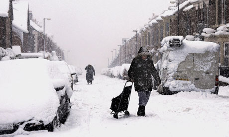
The record loss of Arctic sea ice this summer may mean a cold winter for the UK and northern Europe. The region has been prone to bad winters after summers with very low sea ice, such as 2011 and 2007, said Jennifer Francis, a researcher at Rutgers University.
"We can't make predictions yet … [but] I wouldn't be surprised to see wild extremes this winter," Francis told the Guardian.
This year's ice melt has broken the 2007 record by an an area larger than the state of Texas.
Polar ice experts "thought that it would be many years until we again saw anything like we saw in 2007", said Mark Serreze, director of the National Snow and Ice Data Centre in Colorado.
The unprecedented expanse of ice-free Arctic Ocean has been absorbing the 24-hour sun over the short polar summer. The heat in the water must be released into the atmosphere if the ice is to re-form this autumn. "This is like a new energy source for the atmosphere," said Francis.

This heat and water vapour will affect the all-important jet stream – the west-to-east winds that are the boundary between cold Arctic and the warm mid-latitudes. Others researchers have already shown that the jet stream has been shifting northwards in recent years. Francis and colleagues have recently documented that the jet stream is also slowing down.
"The jet stream is clearly weaker," said Francis. That means weather systems, be it rain or dry conditions, are slow to move on and last longer. Ultimately this can result in "blocking" events, such as the conditions that produced the terrible heatwave in western Russia during the summer of 2010, she said.
This year’s record sea-ice melt might foreshadow a harsh winter in parts of Europe and North America. Recent research, although preliminary, suggests a connection between late-summer Arctic sea-ice extent and the location of areas of high and low atmospheric pressure over the northern Atlantic. The highs and lows can remain relatively fixed for weeks, shaping storm tracks and seasonal weather patterns such as extended cold surges.
Ralf Jaiser, a climate scientist at the Alfred Wegener Institute for Polar and Marine Research in Potsdam, Germany, found a significant correlation in 1989–2011 meteorological data between late-summer Arctic sea-ice extent and atmospheric-pressure anomalies that favour extreme weather such as prolonged cold snaps in winter. He reasons that in autumn, the open Arctic Ocean sheds heat to the high-latitude atmosphere. The warming tends to reduce the large-scale atmospheric-pressure gradient and weakens the dominant westerly winds in the Northern Hemisphere. Those winds normally sweep warm, moist Atlantic air to western Europe; their weakening leaves the region more prone to persistent cold.
“The impacts will become more apparent in autumn, once the freeze-up is under way and we see how circulation patterns have influenced the geographical distribution of sea ice,” says Judith Curry, a climate researcher at the Georgia Institute of Technology in Atlanta. But, she adds, “We can probably expect somewhere in the mid/high latitudes of the Northern Hemisphere to have a snowy and cold winter.”
Ocean organisms are already seeing an impact
Arctic biology is already changing, as the retreat and thinning of sea ice allows more sunlight to penetrate the upper ocean and deprives certain species of habitat, says Jørgen Berge, a marine biologist at the University of Tromsø in Norway. For example, the dominant Arctic zooplankton — the copepods Calanus hyperboreus and C. glacialis — are being replaced by Atlantic C. finmarchicus. Meanwhile, Arctic cod (Arctogadus glacialis) is increasingly being out-competed by its larger Atlantic cousin Gadus morhua.
There’s an important point that bears repeating: This is happening faster than we expected
Computer models that simulate how the ice will respond to a warming climate project that the Arctic will be seasonally ‘ice free’ (definitions of this vary) some time between 2040 and the end of the century. But the observed downward trend in sea-ice cover suggests that summer sea ice could disappear completely as early as 2030, something that none of the models used for the next report by the Intergovernmental Panel on Climate Change comes close to forecasting.

These changes are happening much earlier than scientists thought, said James Overland, an oceanographer and researcher at the University of Washington.
"We've only had a little bit of global warming so far," Overland said.
As the sea ice continues to decline, the jet stream will likely continue to slow more, and shift further north "bringing wild temperature swings and greater numbers of extreme events" in the future he said. "We're in uncharted territory."
Print Page
Hiç yorum yok:
Yorum Gönder